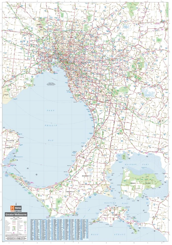
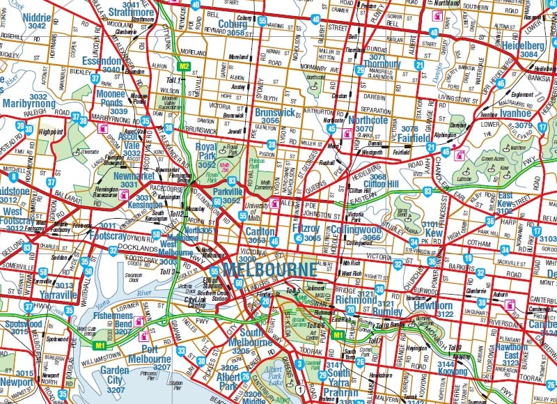
Melbourne and Regional Wall Map
A large wall map of Melbourne and the surrounding region is ideal as a reference and for planning sales and delivery zones. The mapping features suburbs and postcodes, marked camping areas, caravan parks, fuel supplies, major national parks, and an index. The map covers from Phillip Island in the south, to Werribee in the west, to Sunbury in the north and Pakenham in the east.
Available in two finishes and two sizes as follows:
Finish
- Laminated encapsulated - high quality produced by Hema Maps
- Photo paper; Satin 255gsm (unlaminated) - high quality produced by Hema Maps
Size
- Large Map (WxH) - 700 x 1000mm (scale:1:37,300)
- Super Map (WxH) - 1000 x 1430mm (scale: 1:25,000)
All maps are designed and printed in Australia.
Key Features
- Easy-to-read cartography
- Wall map
- Index
- Postcodes
Key Specifications
Edition: 13th
Publication Date: 01/02/2018
Want something different. We do custom maps. Email: [email protected]
Original: $68.45
-65%$68.45
$23.96More Images
Melbourne and Regional Wall Map
A large wall map of Melbourne and the surrounding region is ideal as a reference and for planning sales and delivery zones. The mapping features suburbs and postcodes, marked camping areas, caravan parks, fuel supplies, major national parks, and an index. The map covers from Phillip Island in the south, to Werribee in the west, to Sunbury in the north and Pakenham in the east.
Available in two finishes and two sizes as follows:
Finish
- Laminated encapsulated - high quality produced by Hema Maps
- Photo paper; Satin 255gsm (unlaminated) - high quality produced by Hema Maps
Size
- Large Map (WxH) - 700 x 1000mm (scale:1:37,300)
- Super Map (WxH) - 1000 x 1430mm (scale: 1:25,000)
All maps are designed and printed in Australia.
Key Features
- Easy-to-read cartography
- Wall map
- Index
- Postcodes
Key Specifications
Edition: 13th
Publication Date: 01/02/2018
Want something different. We do custom maps. Email: [email protected]
Product Information
Product Information
Shipping & Returns
Shipping & Returns
Description
A large wall map of Melbourne and the surrounding region is ideal as a reference and for planning sales and delivery zones. The mapping features suburbs and postcodes, marked camping areas, caravan parks, fuel supplies, major national parks, and an index. The map covers from Phillip Island in the south, to Werribee in the west, to Sunbury in the north and Pakenham in the east.
Available in two finishes and two sizes as follows:
Finish
- Laminated encapsulated - high quality produced by Hema Maps
- Photo paper; Satin 255gsm (unlaminated) - high quality produced by Hema Maps
Size
- Large Map (WxH) - 700 x 1000mm (scale:1:37,300)
- Super Map (WxH) - 1000 x 1430mm (scale: 1:25,000)
All maps are designed and printed in Australia.
Key Features
- Easy-to-read cartography
- Wall map
- Index
- Postcodes
Key Specifications
Edition: 13th
Publication Date: 01/02/2018
Want something different. We do custom maps. Email: [email protected]


