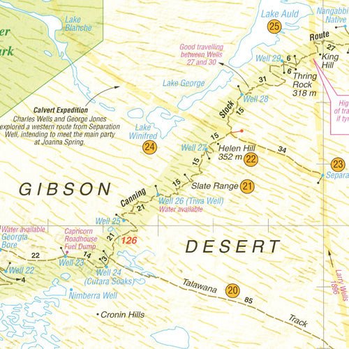
Canning Stock Route Map
The Westprint Canning Stock Route Map is an essential tool for anyone planning to explore one of Australia's most iconic and remote regions. This high-quality map is designed specifically for adventurers and explorers, providing accurate and detailed information about the Canning Stock Route and the surrounding area.
The map covers the entire 1850km length of the Canning Stock Route, from Halls Creek in Western Australia to Wiluna in the east. It includes detailed information about the route's history, as well as important points of interest such as wells, water sources, campsites, and Aboriginal communities.
The Westprint Canning Stock Route Map is an indispensable resource with its detailed information and comprehensive coverage, it will help you navigate the rugged terrain and stunning landscapes of one of Australia's most challenging and rewarding regions.
Overall, the Westprint Canning Stock Route Map is a must-have for anyone looking to explore the Australian outback. With its detailed information, and useful features, it is the ultimate guide to one of Australia's most iconic and unforgettable adventures.
Key Features
- National parks
- Specific 4WD, caravan and camping information
- GPS surveyed roads & tracks
- Heritage & tourist information
Key Specifications
Edition: 6th
Publication Date: 01/01/19
Folded size (WxHxD): 140mm x 250mm x 2mm
Flat size (WxH): 700mm x 1000mm
Weight: 0.09kgs
Original: $14.38
-65%$14.38
$5.03More Images
Canning Stock Route Map
The Westprint Canning Stock Route Map is an essential tool for anyone planning to explore one of Australia's most iconic and remote regions. This high-quality map is designed specifically for adventurers and explorers, providing accurate and detailed information about the Canning Stock Route and the surrounding area.
The map covers the entire 1850km length of the Canning Stock Route, from Halls Creek in Western Australia to Wiluna in the east. It includes detailed information about the route's history, as well as important points of interest such as wells, water sources, campsites, and Aboriginal communities.
The Westprint Canning Stock Route Map is an indispensable resource with its detailed information and comprehensive coverage, it will help you navigate the rugged terrain and stunning landscapes of one of Australia's most challenging and rewarding regions.
Overall, the Westprint Canning Stock Route Map is a must-have for anyone looking to explore the Australian outback. With its detailed information, and useful features, it is the ultimate guide to one of Australia's most iconic and unforgettable adventures.
Key Features
- National parks
- Specific 4WD, caravan and camping information
- GPS surveyed roads & tracks
- Heritage & tourist information
Key Specifications
Edition: 6th
Publication Date: 01/01/19
Folded size (WxHxD): 140mm x 250mm x 2mm
Flat size (WxH): 700mm x 1000mm
Weight: 0.09kgs
Product Information
Product Information
Shipping & Returns
Shipping & Returns
Description
The Westprint Canning Stock Route Map is an essential tool for anyone planning to explore one of Australia's most iconic and remote regions. This high-quality map is designed specifically for adventurers and explorers, providing accurate and detailed information about the Canning Stock Route and the surrounding area.
The map covers the entire 1850km length of the Canning Stock Route, from Halls Creek in Western Australia to Wiluna in the east. It includes detailed information about the route's history, as well as important points of interest such as wells, water sources, campsites, and Aboriginal communities.
The Westprint Canning Stock Route Map is an indispensable resource with its detailed information and comprehensive coverage, it will help you navigate the rugged terrain and stunning landscapes of one of Australia's most challenging and rewarding regions.
Overall, the Westprint Canning Stock Route Map is a must-have for anyone looking to explore the Australian outback. With its detailed information, and useful features, it is the ultimate guide to one of Australia's most iconic and unforgettable adventures.
Key Features
- National parks
- Specific 4WD, caravan and camping information
- GPS surveyed roads & tracks
- Heritage & tourist information
Key Specifications
Edition: 6th
Publication Date: 01/01/19
Folded size (WxHxD): 140mm x 250mm x 2mm
Flat size (WxH): 700mm x 1000mm
Weight: 0.09kgs